SAM's all negative

South Australian Forecast by Craig Brokensha (issued Monday 6th August)
Best Days: South Coast Thursday and Mid Coast keen surfers, South Coast Sunday
Recap
Choppy average 1-2ft waves on the Mid Coast Saturday but a strong new W/SW groundswell pushed in on Sunday with 2-3ft waves through the morning, bigger into the afternoon as winds remained workable.
The South Coast was clean and small on Saturday, slow again Sunday morning but becoming bigger into the afternoon as winds remained offshore.
Today the swell was still strong with clean though inconsistent sets off the South Coast, but not much in between with a continuation of surf in the 3ft range on the Mid Coast but with poor winds.
Today’s Forecaster Notes are brought to you by Rip Curl
This week and weekend (Aug 7 - 12)
Want to receive an email when these Forecaster Notes are updated? Then log in here and update your preferences.
Over the coming period we'll continue to see strong mid-latitude frontal systems pushing across us.
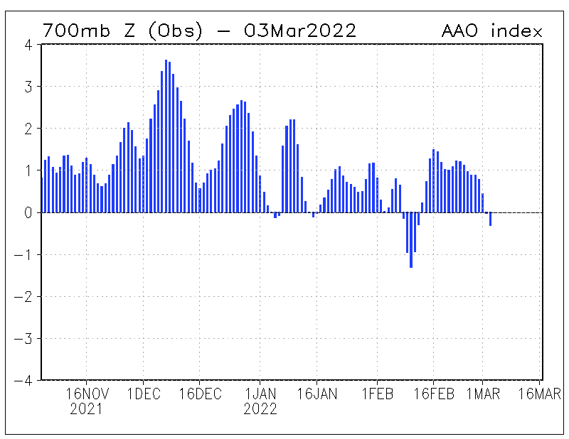
The reason for all this high-riding (latitudinally) frontal activity is a strong negative Southern Annular Mode signal. The (SAM) is an index representing the shift in the polar westerlies (westerly storm track) either south towards the pole away from us, or north towards the equator.
When the SAM is negative as we're currently seeing (below - August to the right), the westerly storm track is shifted further north, hence bringing all this mid-latitude frontal activity.
We'll see this activity continue, producing plenty of windy surf for the Mid Coast, while with the west direction the South Coast will be generally undersized owing to the blocking effects of Kangaroo Island.
Our forecast models are generally over-representing this activity with Middleton expected to be much smaller than shown on the graphs.
Currently the tail end of the strong and slow moving low linked to yesterday's large W/SW groundswell is pushing across us but in a much weaker state.
This will keep weak levels of W/SW swell persisting across both coasts tomorrow morning ahead of a much more significant front pushing through tomorrow evening. The Mid Coast looks to persist at 2ft to occasionally 3ft, with 2ft+ waves off Middleton, more towards 3ft off Cliffs and Goolwa. Conditions will be good in protected spots all day with a fresh W/NW'ly, strengthening into the afternoon and tending more NW with the incoming front.
 This front is currently developing south-west of WA, with a fetch of gale to severe-gale W'ly winds forming off their south coast this evening and early tomorrow morning, pushing east through the Bight while easing back in strength to strong to gale-force.
A large acute W'ly swell should be generated, with mid-period energy building Wednesday ahead of the groundswell proper later in the day, peaking overnight and easing Thursday.
The Mid Coast will see stormy 3ft+ surf through the morning, holding into the afternoon as the groundswell fills in along with strong but easing W/SW winds.
Middleton looks weakish through the morning and only around 2ft on the sets, slowly strengthening and building through the day and hopefully reaching 3ft, if not a touch bigger by late in the day. Conditions will be bumpy though with that W/SW breeze, likely W/NW for a short period early morning.
Thursday looks like the best day to surf this week across the South Coast with the stronger W'ly groundswell component on the ease from the 3ft range off Middleton, bigger towards Cliffs and Goolwa under a gusty and all persistent N/NW offshore.
The Mid Coast will ease back from 2-3ft and there may be windows of slightly more favourable N'ly breeze through the day for keen surfers.
Into Friday the swell will really drop back under a fresh to strong N/NW breeze, giving into a weaker W/SW change through the afternoon.
Moving into the weekend some new less consistent and longer-period W/SW groundswell is due to fill in, overridden by a more local increase in W/SW tending SW swell as a broad but relatively weak polar low and front move across us.
Winds look to take a turn for the worse and shift SW with building levels of mid-period energy Saturday, cleaner with a W/NW breeze and to 3ft to occasionally 4ft off Middleton Sunday, but we'll have a closer look at this Wednesday.
Comments
We've had a lot of swell this winter in SA but the conditions have been garbage. From Middleton to Goolwa it's only surfable on the low tide. On high its' so fat it stops breaking. Winds have been pretty much howling, and we haven't been getting many of those crisp, still winter days with glassy swell. A strange winter. Back in April it pumped but there were no banks to speak of. Waits and Parsons have been very hit and miss (moreso than usual!). What an odd little year we're having!
Recently my best surfs at Middleton have been on super high tides, with 3ft+ swell - perhaps you've been watching/surfing it when smaller?
The lack of any banks from Middleton to Goolwa is really frustrating!! There is no sand anywhere and especially near the point meaning any waves that begin to break back off into big unrideable lumps. I have never seen the rocks along that stretch so exposed, a weird winter indeed.
Third reef Rivermouth!
