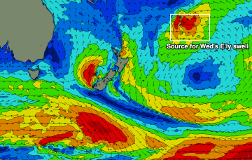
Mid to late afternoon, the leading edge of a new long period E’ly swell will make landfall, though we’re not expecting wave heights to peak until...
Primary tabs
/reports/forecaster-notes/south-east-queensland-northern-new-south-wales/2024/04/15/lovely-mid-week
thermalben
Monday, 15 April 2024
/reports/forecaster-notes/south-east-queensland-northern-new-south-wales/2024/04/12/pumping-surf-full
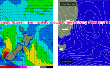
freeride76
Friday, 12 April 2024
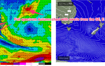
We’ve still got the intense Tasman low in the picture sending plenty of strong SE swell our way, located now off the west coast of the South Island, with a large slow moving high SW of WA and powerful fronts under the SE of the continent.
/reports/forecaster-notes/south-east-queensland-northern-new-south-wales/2024/04/10/first-cool-change
freeride76
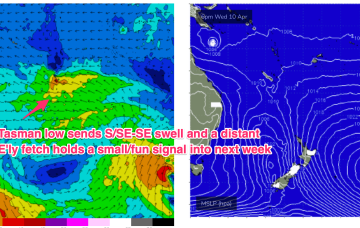
Wednesday, 10 April 2024
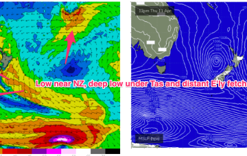
There’s currently a robust Tasman low, still intensifying, moving slowly SE off the Central NSW coast down into the Tasman Sea towards New Zealand. Gales to severe gales wrapping the SW flank of the low will supply plenty of strong S’ly swell through the rest of the week.
/reports/forecaster-notes/south-east-queensland-northern-new-south-wales/2024/04/08/swells-across-the
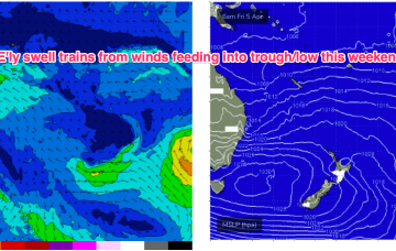
freeride76
Monday, 8 April 2024
That’s allowing plenty of space for low pressure development in the Tasman and as a front pushes through and combines with the remnants of a trough we’ll see a robust low develop through tomorrow, with gales expected close to the coast.
/reports/forecaster-notes/south-east-queensland-northern-new-south-wales/2024/04/05/tricky-generally
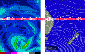
freeride76
Friday, 5 April 2024
The moist onshore flow from this set-up is flowing into a coastal trough and interior low bringing onshore winds and rain as well as developing E swell. We’ll eventually see the low and trough clear the coast bringing better winds Sun/Mon with some strong S swell on the menu for next week from Tasman Sea and deeper sources.
/reports/forecaster-notes/south-east-queensland-northern-new-south-wales/2024/04/03/tricky-outlook
Craig
Wednesday, 3 April 2024
The Mid North Coast will see stormy, poor surf developing later week and into the weekend, improving slowly from Sunday.

/reports/forecaster-notes/south-east-queensland-northern-new-south-wales/2024/04/01/some-tiny-days
freeride76
Monday, 1 April 2024
A complex inland trough low tied to tropical sources exits the coast as a strong high moves into the Bight. Following that a coastal trough in the Northern Tasman then deepens, likely into a surface low which may drift southwards bringing E swells to the entire region, possibly followed by a return S swell as the low gets captured by an approaching front.
/reports/forecaster-notes/south-east-queensland-northern-new-south-wales/2024/03/29/mellow-easter
freeride76
Friday, 29 March 2024
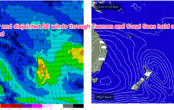
Only minor action from the E is expected from a northwards positioned SE flow in the Coral Sea. Adding to that source south of the border we’ll see some small S’ly pulses over the Easter long weekend.
/reports/forecaster-notes/south-east-queensland-northern-new-south-wales/2024/03/27/small-spell-se
thermalben
Wednesday, 27 March 2024
The swell regime for the next few days throughout SE Qld will remain small out of the east with just enough size for small runners on the semi-exposed points.
/reports/forecaster-notes/south-east-queensland-northern-new-south-wales/2024/03/25/tradewind-swells
freeride76
Monday, 25 March 2024
We’ve got an extensive high pressure belt with weak cells in the Tasman and near Indian Ocean and a stronger cell in the Bight. Compared to summer high pressure we’re seeing a slight seasonal shift northwards in the belt although later in the week the strong high in the Bight does move towards Tasmania at a more typical summer latitude.